So I spent some time today figuring out where to go next, and I've decided (I think) on a ride up to Crested Butte. Sadly, I expect the round trip to take about four days and I have some commitments in town that would make it difficult to do until late next week. It's just as well, I suppose, who wants to deal with the Memorial Day traffic? Besides, it's Mountain Film here; I might try to take in some movies.
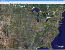
I happened upon this really neat site, Runningmap.com, which is a lot like Google maps except you can see mileage on your route more clearly and it even has an amazingly cool and useful elevation chart! Unfortunately, I don't think there's a way to make your lines of travel conform automatically to roads, so you either have to be super diligent when making lines or just resign yourself to a more "as the crow flies" kind of route. Nevertheless, that's how I was able to estimate how long it would take to get to Crusty Butt. The elevation chart revealed a very serious climb that I can now prepare for. It's much more useful than simple mileage, particularly when planning on possible campsites.
I guess that's all for now. I'm kind of digging this new-fangled blogging fad that all the kids are into these days. Now I can finally bug the anonymous masses with the vapid internal monologue that might otherwise go unrecorded!
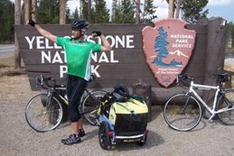
Here's another Yellowstone photo, courtesy of
 Mr. Fred Finn.


1 comment:
Who is that handsome devil? I acientally erased all my pictures... i was so pissed. I'm glad to see some of them survived with you!!
I hope I can make this trip with you.
Post a Comment